


st jean les arcs

clintest
User
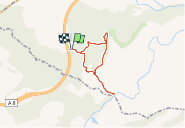

Length
7.7 km

Max alt
181 m

Uphill gradient
188 m
Km-Effort
10.2 km

Min alt
39 m

Downhill gradient
189 m
Boucle
Yes
Creation date :
2025-05-07 11:19:35.735
Updated on :
2025-05-07 13:34:57.236
2h14
Difficulty : Medium

FREE GPS app for hiking
 SityTrail
IGN / Geographical institutes
SityTrail Plus
The world is yours!
About
Trail Walking of 7.7 km to be discovered at Provence-Alpes-Côte d'Azur, Var, Les Arcs-sur-Argens. This trail is proposed by clintest.
Photos


Positioning
Country:
France
Region :
Provence-Alpes-Côte d'Azur
Department/Province :
Var
Municipality :
Les Arcs-sur-Argens
Location:
Unknown
Start:(Dec)
Start:(UTM)
295156 ; 4811323 (32T) N.
Comments